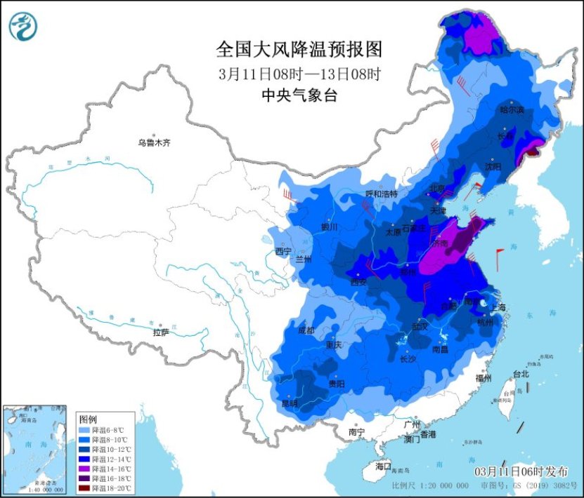
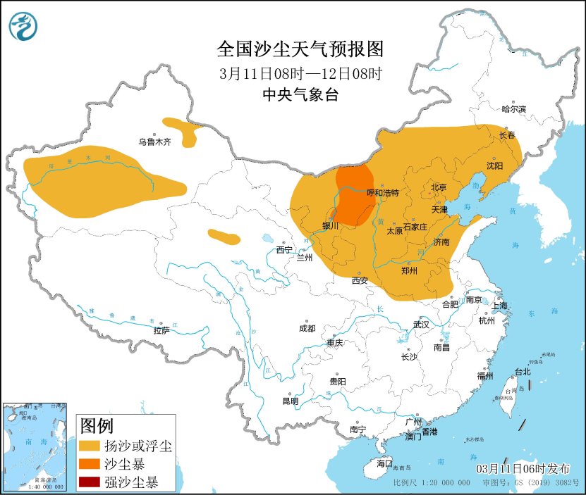
CCTV News:The Central Meteorological Observatory issued daily weather warnings. At present, the three warnings of cold wave blue, dust blue and strong wind yellow at sea have been issued at the same time, which shows that the cold wave is strong. Meteorological monitoring shows that yesterday, gusts of 6 ~ 8 occurred in eastern Xinjiang and southern Xinjiang basin, parts of Inner Mongolia, northwestern Shanxi, Beijing-Tianjin-Hebei, Heilongjiang, Jilin, Liaoning, north-central Shandong, northern Henan and other places, and 9 ~ 11 in eastern Inner Mongolia and northwestern Shandong; Sand blowing or floating dust weather occurred in some of the above areas, and sandstorms occurred in Hohhot and Xilin Gol League in Inner Mongolia. This morning, some areas in Inner Mongolia, northern Hebei, northern Shandong and other places experienced a temperature drop of 6 ~ 10 C, and the local drop in central and eastern Inner Mongolia reached 12 ~ 20 C.
Today and tomorrow, the impact of the cold wave will continue. The temperature in most parts of the central and eastern regions will drop by 6 ~ 10℃ successively, and the temperature in North China, Huanghuai, Jianghuai and other places will drop by 12℃, partially exceeding 16℃. There are 4 ~ 6 winds and gusts of 7 ~ 9 in these areas, and there are dusty weather in northwest, north China and northeast China. There are 6 ~ 8 winds and 9~11 gusts in most offshore areas of China; Today, the influence of cold air will still be mainly concentrated in the northern region. The lowest temperature in this process will appear on the morning of 13th, and the lowest temperature 0℃ line will be located in the southwest of Shaanxi, the west of Henan and the south of Hebei to Tianjin, and the lowest temperature in eastern Shandong and northeastern Jiangsu will also reach about 0℃.
Meteorologists reminded that before the arrival of cold air yesterday, the temperature in central and southern North China and Huanghuai was still rising. The highest temperature in Shahe, Hebei Province once reached 32.8 C, just like summer; However, this is only the last madness. Today, the highest temperature in the above-mentioned areas will be halved, especially in Shandong. The public should pay attention to the temperature changes and adjust their clothes in time. In addition, due to the influence of the cold wave, most of the north is windy, so it is necessary to stay away from temporary structures when going out.
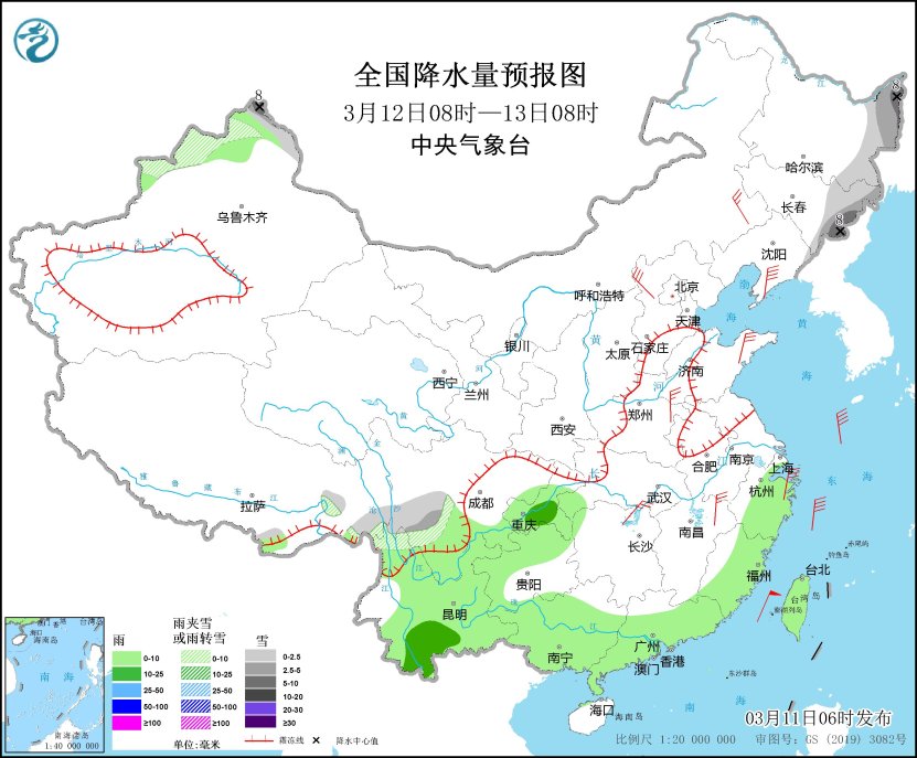
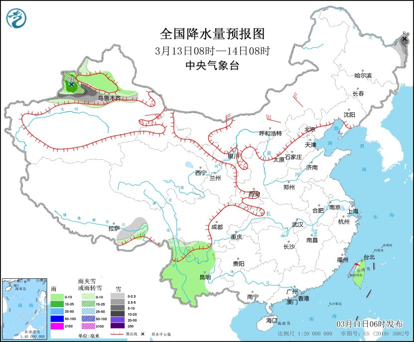
In terms of precipitation, today and tomorrow, there will be small to moderate rain and local heavy rain in the eastern part of southwest China, Jiangnan and South China, and the rain belt will gradually press southward and its intensity will weaken, and the precipitation will end on the 13th. Precipitation in the northern region mainly occurs in the northeast and northern Xinjiang. In the next three days, there will be small to medium snow and local heavy snow in the eastern part of the northeast. From tomorrow, the rain and snow in northern Xinjiang will gradually spread, and some areas in northern Xinjiang and other places will have small to medium snow or sleet, and local snow will fall. Please pay close attention to the weather forecast and early warning information released by the local meteorological department, and pay attention to prevent the adverse effects of slippery roads and icing caused by rain and snow on traffic.